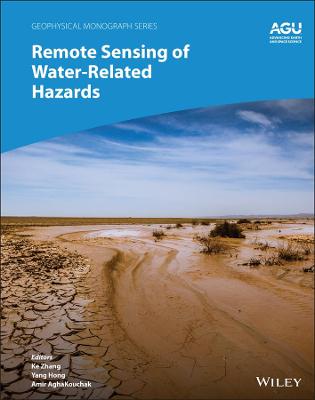
Remote Sensing of Water-Related Hazards
 -15%
portes grátis
Remote Sensing of Water-Related Hazards
Zhang, Ke; AghaKouchak, Amir; Hong, Yang
John Wiley & Sons Inc
04/2022
272
Dura
Inglês
9781119159124
15 a 20 dias
844
Descrição não disponível.
List of Contributors vii
Preface xi
1. Interdisciplinary Perspectives on Remote Sensing for Monitoring and Predicting Water-Related Hazards 1
Ke Zhang, Yang Hong, and Amir AghaKouchak
Part I Remote Sensing of Precipitation and Storms
2. Progress in Satellite Precipitation Products over the Past Two Decades: Evaluation and Application in Flash Flood Warning 13
Guoqiang Tang, Tsechun Wang, Meihong Ma, Wentao Xiong, Feng Lyu, and Ziqiang Ma
3. Observations of Tornadoes and Their Parent Supercells Using Ground-Based, Mobile Doppler Radars 31
Howard B. Bluestein
Part II Remote Sensing of Floods and Associated Hazards
4. Remote Sensing Mapping and Modeling for Flood Hazards in Data-Scarce Areas: A Case Study in Nyaungdon Area, Myanmar 71
Ke Zhang, Zaw Myo Khaing, and Zhijia Li
5. Multisensor Remote Sensing and the Multidimensional Modeling of Extreme Flood Events: A Case Study of Hurricane Harvey--Triggered Floods in Houston, Texas, USA 87
Mengye Chen, Zhi Li, and Shang Gao
6. A Multisource, Data-Driven, Web-GIS-Based Hydrological Modeling Framework for Flood Forecasting and Prevention 105
Zhanming Wan, Xianwu Xue, Ke Zhang, Yang Hong, Jonathan J. Gourley, and Humberto Vergara
7. An Ensemble-Based, Remote-Sensing-Driven, Flood-Landslide Early Warning System 123
Ke Zhang, Guoding Chen, Yi Xia, and Sheng Wang
8. Detection of Hazard-Damaged Bridges Using Multitemporal High-Resolution SAR Imagery 135
Wen Liu, Kazuki Inoue, and Fumio Yamazaki
Part III Remote Sensing of Droughts and Associated Hazards
9. Drought Monitoring Based on Remote Sensing 151
Xin Li, Ran Tao, and Ke Zhang
10. Remote Sensing of Vegetation Responses to Drought Disturbances Using Spaceborne Optical and Near-Infrared Sensors 169
Ke Zhang, Linxin Liu, Yunping Li, and Ran Tao
11. Recent Advances in Physical Water Scarcity Assessment Using GRACE Satellite Data 187
Emad Hasan and Aondover Tarhule
12. Study of Water Cycle Variation in the Yellow River Basin Based on Satellite Remote Sensing and Numerical Modeling 203
Meixia Lv and Zhuguo Ma
13. Assessing the Impact of Climate Change-Induced Droughts on Soil Salinity Development in Agricultural Areas Using Ground and Satellite Sensors 223
Dennis L. Corwin and Elia Scudiero
Index 245
Este título pertence ao(s) assunto(s) indicados(s). Para ver outros títulos clique no assunto desejado.
precipitation; flood mapping; storms; tornados; storm forecasting; storm early warning; flood prediction; landslide prediction; cascading hazard; water cycle variation; water scarcity; drought conditions; drought impacts; water hazard sensors
List of Contributors vii
Preface xi
1. Interdisciplinary Perspectives on Remote Sensing for Monitoring and Predicting Water-Related Hazards 1
Ke Zhang, Yang Hong, and Amir AghaKouchak
Part I Remote Sensing of Precipitation and Storms
2. Progress in Satellite Precipitation Products over the Past Two Decades: Evaluation and Application in Flash Flood Warning 13
Guoqiang Tang, Tsechun Wang, Meihong Ma, Wentao Xiong, Feng Lyu, and Ziqiang Ma
3. Observations of Tornadoes and Their Parent Supercells Using Ground-Based, Mobile Doppler Radars 31
Howard B. Bluestein
Part II Remote Sensing of Floods and Associated Hazards
4. Remote Sensing Mapping and Modeling for Flood Hazards in Data-Scarce Areas: A Case Study in Nyaungdon Area, Myanmar 71
Ke Zhang, Zaw Myo Khaing, and Zhijia Li
5. Multisensor Remote Sensing and the Multidimensional Modeling of Extreme Flood Events: A Case Study of Hurricane Harvey--Triggered Floods in Houston, Texas, USA 87
Mengye Chen, Zhi Li, and Shang Gao
6. A Multisource, Data-Driven, Web-GIS-Based Hydrological Modeling Framework for Flood Forecasting and Prevention 105
Zhanming Wan, Xianwu Xue, Ke Zhang, Yang Hong, Jonathan J. Gourley, and Humberto Vergara
7. An Ensemble-Based, Remote-Sensing-Driven, Flood-Landslide Early Warning System 123
Ke Zhang, Guoding Chen, Yi Xia, and Sheng Wang
8. Detection of Hazard-Damaged Bridges Using Multitemporal High-Resolution SAR Imagery 135
Wen Liu, Kazuki Inoue, and Fumio Yamazaki
Part III Remote Sensing of Droughts and Associated Hazards
9. Drought Monitoring Based on Remote Sensing 151
Xin Li, Ran Tao, and Ke Zhang
10. Remote Sensing of Vegetation Responses to Drought Disturbances Using Spaceborne Optical and Near-Infrared Sensors 169
Ke Zhang, Linxin Liu, Yunping Li, and Ran Tao
11. Recent Advances in Physical Water Scarcity Assessment Using GRACE Satellite Data 187
Emad Hasan and Aondover Tarhule
12. Study of Water Cycle Variation in the Yellow River Basin Based on Satellite Remote Sensing and Numerical Modeling 203
Meixia Lv and Zhuguo Ma
13. Assessing the Impact of Climate Change-Induced Droughts on Soil Salinity Development in Agricultural Areas Using Ground and Satellite Sensors 223
Dennis L. Corwin and Elia Scudiero
Index 245
Preface xi
1. Interdisciplinary Perspectives on Remote Sensing for Monitoring and Predicting Water-Related Hazards 1
Ke Zhang, Yang Hong, and Amir AghaKouchak
Part I Remote Sensing of Precipitation and Storms
2. Progress in Satellite Precipitation Products over the Past Two Decades: Evaluation and Application in Flash Flood Warning 13
Guoqiang Tang, Tsechun Wang, Meihong Ma, Wentao Xiong, Feng Lyu, and Ziqiang Ma
3. Observations of Tornadoes and Their Parent Supercells Using Ground-Based, Mobile Doppler Radars 31
Howard B. Bluestein
Part II Remote Sensing of Floods and Associated Hazards
4. Remote Sensing Mapping and Modeling for Flood Hazards in Data-Scarce Areas: A Case Study in Nyaungdon Area, Myanmar 71
Ke Zhang, Zaw Myo Khaing, and Zhijia Li
5. Multisensor Remote Sensing and the Multidimensional Modeling of Extreme Flood Events: A Case Study of Hurricane Harvey--Triggered Floods in Houston, Texas, USA 87
Mengye Chen, Zhi Li, and Shang Gao
6. A Multisource, Data-Driven, Web-GIS-Based Hydrological Modeling Framework for Flood Forecasting and Prevention 105
Zhanming Wan, Xianwu Xue, Ke Zhang, Yang Hong, Jonathan J. Gourley, and Humberto Vergara
7. An Ensemble-Based, Remote-Sensing-Driven, Flood-Landslide Early Warning System 123
Ke Zhang, Guoding Chen, Yi Xia, and Sheng Wang
8. Detection of Hazard-Damaged Bridges Using Multitemporal High-Resolution SAR Imagery 135
Wen Liu, Kazuki Inoue, and Fumio Yamazaki
Part III Remote Sensing of Droughts and Associated Hazards
9. Drought Monitoring Based on Remote Sensing 151
Xin Li, Ran Tao, and Ke Zhang
10. Remote Sensing of Vegetation Responses to Drought Disturbances Using Spaceborne Optical and Near-Infrared Sensors 169
Ke Zhang, Linxin Liu, Yunping Li, and Ran Tao
11. Recent Advances in Physical Water Scarcity Assessment Using GRACE Satellite Data 187
Emad Hasan and Aondover Tarhule
12. Study of Water Cycle Variation in the Yellow River Basin Based on Satellite Remote Sensing and Numerical Modeling 203
Meixia Lv and Zhuguo Ma
13. Assessing the Impact of Climate Change-Induced Droughts on Soil Salinity Development in Agricultural Areas Using Ground and Satellite Sensors 223
Dennis L. Corwin and Elia Scudiero
Index 245
Este título pertence ao(s) assunto(s) indicados(s). Para ver outros títulos clique no assunto desejado.


